Definitions
The search results will display a list of matching objects, including a selection of values for each object.
Click the object name to see a detailed report of the object.
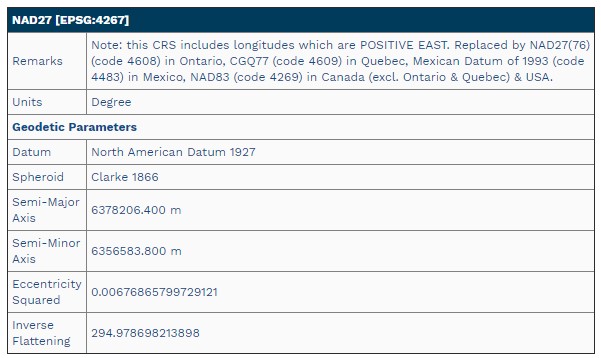
The top of the page will display a tabular summary of the main parameters. Below is an example.
At the bottom of the page in expandable sections are additional details about the object and its related parameters. This section also contains Actions for exporting or sharing the data.
URL - The url button will open a direct link to the object in a new tab or window.
Print- The print function will create a clean report of the object in a new tab or window. In most browsers use CTRL+P or the browser right-click context menu to print th
GML - This will open a GML definition of the object in a new tab or window.
WKT - This will open a WKT definition of the object in a new tab or window.
See below for more information about an object or parameter.
Object Types
-
Units of Measure
-
Prime Meridians - The Prime Meridian represents the line of longitude that is designated as 0 degrees. All other lines of longitude are expressed by the angle by which they deviate from the Prime Meridian. Together with the equator of an Ellipsoid, the Prime Meridian defines the origin of a Geodetic Coordinate System. A Prime Meridian is defined by the angle that separates it from the Greenwich Meridian.
-
Ellipsoids - An Ellipsoid gives a Datum its size and shape. An Ellipsoid does not have an origin and cannot be used as a base model for coordinates on its own.
-
Datums - A Datum is the base model that maps are built on. All coordinate systems must have a datum associated with them to be related to any other map. Without a known datum, coordinates are meaningless.
-
Coordinate Transformations - Coordinate Transformations (Concatenated, Datum, Parametric or Vertical) - Parameters to transform coordinates from one Coordinate System to another.
-
Coordinate Systems (Coordinate Reference Systems) - A Coordinate System is a complete definition needed to express the context of a set of map data.
- Geodetic Coordinate System - A two or three-dimensional coordinate system defined by an ellipsoid, the equatorial plane of the ellipsoidal and a plane defined along the polar axis (a meridional plane).
- Geocentric Coordinate System- A geocentric coordinate system is a 3-dimensional coordinate system represented by X,Y,Z coordinates. The origin of the system is the center of the earth.This is also refered to as earth-centered, earth-fixed (ECEF).
- Projected Coordinate System- A map projection is a systematic transformation of a 3-dimensional coordinate system into locations on a plane (2-dimensional surface). All map projections contain some necessary distortion in order to achieve this. They may preserve different properties, or minimize distortion in particular areas, depending on the purpose of the projection.
-
Point Styles (Coordinate Points) - A Point Style is used to define the orientation of axes used and the type of units used in the system.
-
Usage - Defines how and where a coordinate system, datum, or transformation, is intended to be used. A coordinate system or transformation can be tied to multiple usages. A usage includes both a scope and an area of use.
-
Scope - A description of the primary purpose to which a coordinate reference system, datum, or coordinate operation is applied.
-
Areas of Use - Define a geographic area of use for a particular object.
Object Parameters
The results window will display a selection of defining parameters specific to the object type. See below for more information about a parameter.
General Parameters
- Name - Descriptive name of the object.
- EPSG Code- Identifier code assigned to the object by the EPSG. Codes are unique by object type.
- Deprecated - This value will be True if the object has been deprecated. Deprecated objects are not searched by default, and searching deprecated objects must be enabled. Following the EPSG standards, object definitions with errors or that have been superseded are deprecated rather than removed in order to maintain a complete datasource.
-
Ensemble - A datum ensemble is a group of multiple realizations of the same reference system which are not significantly different when using an approximation.
- GML - This button will load an XML definition in Geographic Markup Language.
- WKT - This button will display Coordinate Reference system or transformations in WKT (Well Known Text) format.
- Remarks - Additional notes about the object. This may include supplementary information.
- Revision Date - Date of most recent revision to the object definition.
- Identifiers - Authority codes linked to the object definition. These are reference codes used to define the object by different authorities.
- History - this is a history of revisions to the object definition. The history will include things like Authority, Report Date, Reporter and Actions takes to change the object definition.
- URL- right click on the url button and choose copy url or copy link to save a direct link to the object definition. Some browsers also support CTRL - click to open the object directly in a new browser tab.
- Units per - Units of measure will display a standardized conversion factor to compare across definitions. For Angular units this is units per degree, for linear units it is units per meter. For scalar units, this is units per unity (scalar units do not have a measured unit definition).
- Abbrev - Unit of measure definitions . This will also display in the object definition in parenthesis at the top next to the object name.
- Longitude(deg) - Longitude of Prime Meridian relative to the Greenwich Prime Meridian.
- Longitude Units - unit of measure connected to the Prime Meridian definition.
- Semi-Major(m)- dimension of the semi-major axis (a) in meters. This may be listed in other units on the object definition page.
- Semi-Minor (m)- dimension of the semi-minor axis (b) in meters. This may be listed in other units on the object definition page.
- Radius - sphere objects are defined by only a radius, which will be listed for both the semi-major and semi-minor axes in the search results.
- Inverse Flattening - flattening is the relative flattening of a sphere to form the ellipsoid. The inverse flattening and equatorial radius may be used to define to ellipsoid. 1/f = a/(a/b) . The object definition page will indicate whether this value is used in the ellipsoid definition, or calculated from the semi-major and semi-minor axis values.
- Axis Units / Radius Units- unit of measure used in the axis or radius definition. On the search results page all units will be converted to meters for comparison.
- Units - units of measure for the point style. This will vary per point style type of Cartesian, Geodetic, Projected, Vertical or String. This may include X , Y , and Z Units, Lat and Lon units, Northing and Easting Units, or Height Units.
- Dimensions - geodetic and projected point styles may be 2D or 3D.
- Axes, Orientation(s)-Geodetic, Projected and Vertical point styles need to define the labeling and orientation of axes.
- Min Point, Max Point - The bounding box is defined by a lower left coordinate (min point) and upper right coordinate (max point) in WGS 84 Coordinate Reference System.
- Map display - the object definition page will include a map display showing the bounding box in red and coordinates in degrees on the edges of the map.
- Bounding Box Units - units of measure for the bounding box definition.
- Ellipsoid- Name of Ellipsoid used in the datum definition. The full ellipsoid definition will be included in a subsection on the Horizontal Datum definition page.
- Prime Meridian Name - Name of Prime Meridian used in the datum definition. If this is different than Greenwich, it will also appear in parenthesis in the datum name. The full Prime Meridian definition will be included in a subsection on the Horizontal Datum definition page.
- Prime Meridian Value(deg) - Longitude of Prime Meridian in degrees relative to the Greenwich Prime Meridian.
Vertical Datum objects do not have special parameters. The vertical datum is realized through the transformation.
- Geodetic - Name of base geodetic coordinate system for the projected system. The full base geodetic coordinate system is listed in a subsection of the projected coordinate system definition page.
- Datum - Name of datum used in the coordinate system definition. The full Horizontal or Vertical datum definition is available as a subsection on the Coordinate System definition page.
- Units - units for the coordinate values in the Coordinate System.
- Area of Use - definition of approximate bounding geometry for the location where the projection is intended to be used.
- Dimensions- number of dimensions used in the coordinate system. This will be 2 if the system is 2D or 3 if the system is 3D.
- Point Style - point style definition used by the coordinate system. A Point Style is used to define the orientation of axes used and the type of units used in the system.
- Projection parameters - this will display a table representing the defining parameters for the projection. For more information about a specific projection and its defining parameters, see Map Projections in the Geographic Calculator Knowledgebase
- Source/ Target- Name of source and target coordinate systems. The full Coordinate System definitions are provided as subsections on the Transformation definition page. Most transformations can be performed in the forward and reverse direction, and the convention is to list the Target as the more common system.
- Type - name for they type of transformation method used. The full details are listed in the Coordinate Operation section on the Transformation definition page.
- Is 2D - this will be true if the transformation is 2D, and false if the transformation uses more than 2 dimensions.
- Accuracy - accuracy of the transformation in meters. This is reported from the authority.
- Area of Use - definition of approximate bounding geometry for the location where the transformation is intended to be used.
- Interpolation Type - Vertical Transformation definitions report the type of interpolation used